California is bracing for a stronger and longer-lasting atmospheric river event this weekend, which is expected to bring mudslides, damaging winds, and heavy mountain snow and has already triggered flood watches for nearly 40 million people.
The Weather Prediction Center has issued a rare Level 4 of 4 risk of excessive rainfall for Santa Barbara and Oxnard on Sunday.
A more widespread Level 3 risk exists for much of coastal California, including San Francisco down through Los Angeles.
A level 4 us unprecedented …
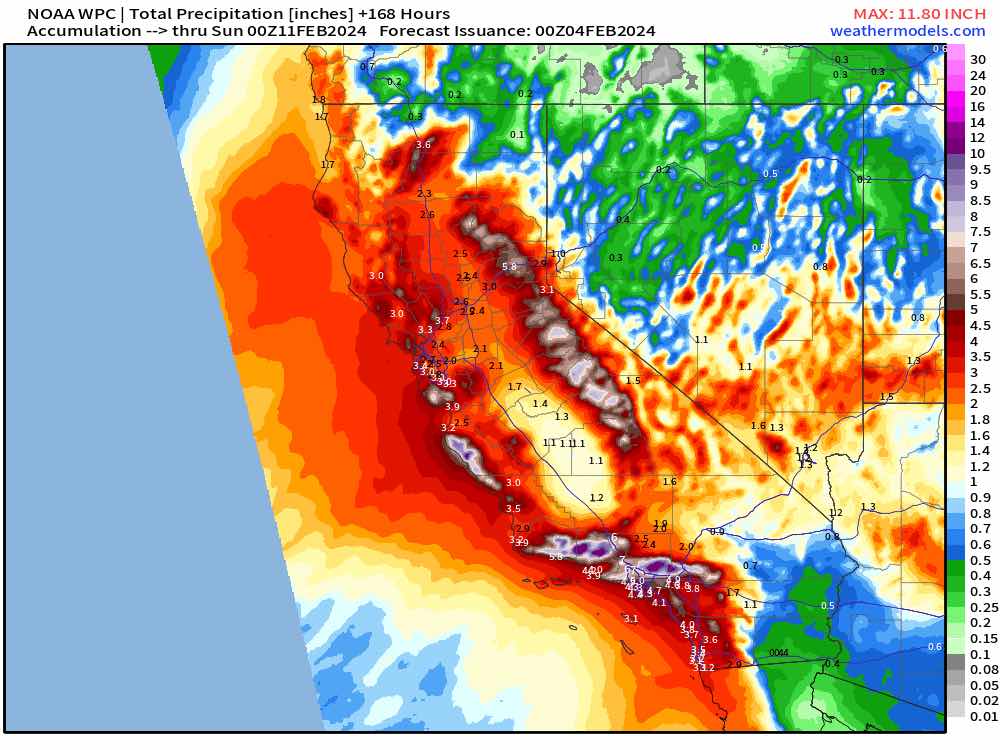
Heavy precipitation is expected to move across the San Francisco Bay area and the Central Coast of California tonight through Sunday, eventually reaching southern California Sunday into Monday.
Some of the heaviest rain is expected on Sunday in areas around the Los Angeles metro area, especially to the north. This heavy rain will result in considerable flash, urban, and small stream flooding with debris flows and mudslides.
The National Weather Service also warns that river flooding is also likely.
The precipitation will smash into the higher terrain as heavy wet snow. The heavy snow will spread across the Sierra Nevada tonight through Monday with accumulation rates of 2-3″/hour.
Winds will also be strong, gusting to 60 mph at times; this will produce whiteout conditions and near impossible travel above 5’000 feet. Southern California ranges will see heavy snow later Sunday through to early Tuesday above 7,000 feet.
There will also be damaging winds and high surf at the coast.

Up to 5 inches of rain is likely from the Central California Coast Range south into the Transverse Range and portions of the Los Angeles metro area, while some upslope areas of those mountain ranges could see more than 10 inches of rain throughout the event.
"Life-threatening flash and urban flash flooding possible in the high risk area," the WPC warned.
Comments
Post a Comment
Thank you for commenting! Keep reading the fishwrappers!